Infrastructure projects are multi-disciplinary, multi-organisational endeavours where each party generates enormous volumes of data. But deciphering this data to gain clear insights for decision-making as soon as possible is far beyond the capacity of any human alone.
So engineers have turned to digital solutions. The building information modelling (BIM) philosophy is used to bring project data together into a common environment. This allows engineers to identify any clashes between the disciplines earlier in the process, avoiding costly mistakes on site.
Reaching a common understanding around ground risk, however, requires an ability to rapidly and flexibly present the subsurface information in a highly visual and realistic way alongside the engineering data.
After all, if a picture is worth a thousand words, then a 3D interactive model can perhaps be worth a million.
Sharing their insights into how digital solutions are transforming communication and collaboration in civil projects today are:
- Sean Buchanan, Civil & Environmental Project Geologist at Seequent;
- Alex Riach, Business Analyst in Information Management at WSP; and
- Guy Smith, Hydrogeology Data Specialist in WSP’s Global Information Management team.
"Digital solutions improve the geotechnical workflow. Period."
Alex RiachBusiness Analyst, Information Management, WSP
The biggest challenges in project stakeholder communication
Ensuring alignment in conceptual understanding among stakeholders is crucial for informed decision-making. Without a shared understanding of the project’s big picture, stakeholders may not be able to make well-informed decisions, leading to potential conflicts and inefficiencies.
Getting lost in translation
One of the most common challenges in project communication is that the inherent uncertainty in subsurface conditions doesn’t translate well into engineering projects, which typically seek certainty and predictability.
The response is typically to embed ground-related data in long-winded text-based reports. But when key insights are buried within a PDF file, stakeholders can lose sight of this crucial information. This leads to a lack of clarity when identifying and mitigating ground risk, particularly in the early stages of a project, which drives delays in finding solutions and, ultimately, puts project milestones at risk.
No time for testing improvements
Another significant challenge in project communication is the lack of time to evaluate new and improved ways of working. Paired with creeping deadlines and limited project time frames, this discrepancy can create friction and misunderstandings during project execution. In addition, the traditional contracting of risk doesn’t provide sufficient incentives for change within the industry, further complicating the adoption of innovative practices.
To overcome these challenges and facilitate successful project outcomes, clear and effective communication strategies are essential at every step of the project.
Effective communication and its importance in civil projects
When robust communication programs are implemented early in a project, they help keep technical teams and other stakeholders engaged and informed throughout the project lifecycle.
Classic deliverables, like lengthy reports, can hinder effective communication between all parties when reviewing things such as ground conditions. The delay in report reviews often leads to misunderstandings and further delays, reducing the overall efficiency of the process.
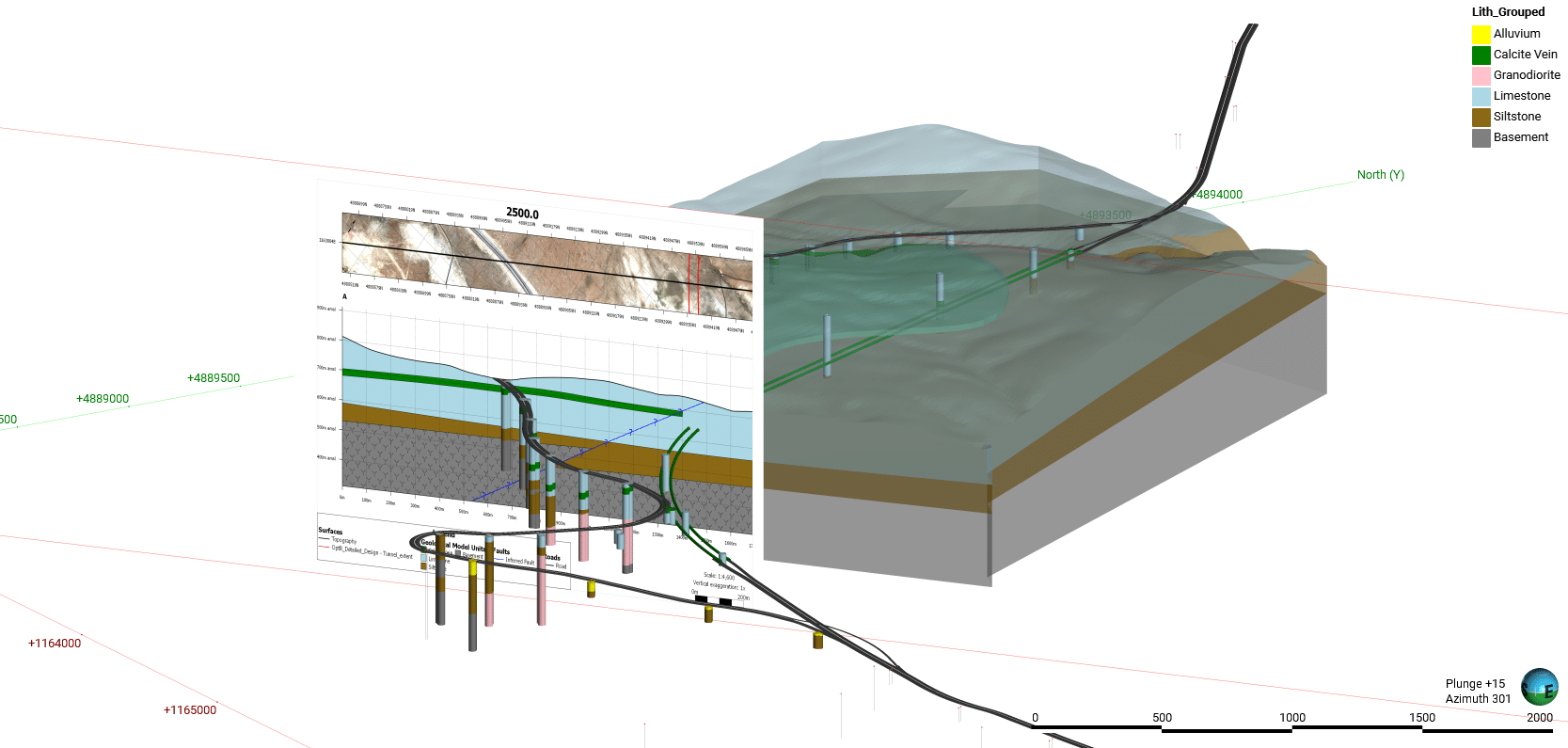
Instead, because modern 3D ground modelling software allows you to combine your geological engineering judgments and factual data together in a single model, it’s possible to show the measured data and the interpreted areas in one view. This makes it possible to communicate to others where your model is data driven, versus where you are applying your experience.
This is particularly impactful when highlighting different locations, and showing where missing data is introducing more uncertainty and risk into your project.

Seequent’s 3D ground modelling software Leapfrog Works shows dynamic 3D models, helping to communicate risks to stakeholders of all technical levels.
Timely and clear communication is essential for minimising conflicts and boosting project efficiency. By ensuring that everyone is on the same page from the start, projects can proceed more smoothly and effectively, ultimately leading to better outcomes.
"The value of everyone being on the same page in terms of big-picture understanding cannot be understated. It’s the only way to ensure that each person with a seat at the table is truly an informed decision-maker, and not just along for the ride."
Guy SmithHydrogeology Data Specialist—Global Information Management, WSP
Differences in communication between technical and non-technical stakeholders
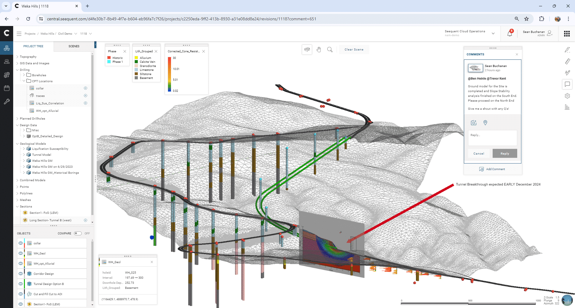
Creating a view of your 3D ground model in the cloud helps bring abstract geological concepts to life and makes them much more accessible, aiding quicker understanding and decision-making without overwhelming stakeholders with details.
Overall, while technical stakeholders thrive on detailed, technical documentation, non-technical stakeholders need visual, simplified, and interactive methods to understand complex geological data and project implications.
"Highly visual 3D models of the subsurface can enable greater understanding and bring ground risk to life."
Sean BuchananCivil & Environmental Project Geologist, Seequent
The challenge of this collaborative communication is even more apparent for ground engineering teams, as they need to communicate with other technical stakeholders — such as civil or structural engineering colleagues — as well as non-technical stakeholders like project managers or clients.
Here are a few more examples of the differences to expect when ground engineering teams are communicating with technical and non-technical stakeholders.
Understanding and details
Ground engineering team:
Technical stakeholders:
Non-technical stakeholders:
- Appreciate risks from subsurface uncertainty
- Focused on the geotechnical and geoscience data
- Can think in 3D when reviewing 2D information
- Need to make decisions relating to interpretation and overcome modeller biases
- Accustomed to detailed reports and technical data for their own engineering discipline
- Work in high levels of accuracy in engineering design
- May struggle to understand complex subsurface information through traditional reports
- Prefer visual aids to grasp concepts
- Focus on understanding the bigger picture
- Need to see the information in context to believe it and understand it
Visualisation tools
Ground engineering team:
Technical stakeholders:
Non-technical stakeholders:
- Can interpret 2D figures, maps, and detailed geoscience and geotechnical documentation
- Use 3D visualisation to explain geological concepts and risk to others
- Can interpret 2D figures, maps, and detailed technical engineering documentation
- Commonly use 3D building information models (BIM) for clash detection in multi-disciplinary engineering design
- Benefit from 3D visualisations to help them understand ground risks
- May only comprehend the relevance of 2D information when it is presented in the context of a 3D site model
Traditional communication approaches
Ground engineering team:
Technical stakeholders:
Non-technical stakeholders:
- Generalist tools like emails, screenshots, presentations, Excel, and written reports
- Demonstration and screen sharing with specialist geotechnical software
- Engineering reports, plans, and 2D drawings that are derived from 3D models
- Are comfortable with complex technical jargon and in-depth engineering analysis
- Need a simplified, visual approach such as high-level reporting via dashboards
- Prefer information in a way that is simpler to understand, with clear, jargon-free language
- Don’t have time or inclination to learn specialist software
Engagement strategies
Ground engineering team:
Technical stakeholders:
Non-technical stakeholders:
- Provide situational clarity to reviewers through a common 3D contextual view
- Remove barriers of specialist modelling software in the review process
- Engage through combining engineering and subsurface data together in a common 3D contextual view
- Controlled document management in common data environments to mitigate potential for misuse or liability
- Engage through visual, interactive presentations with simplified explanations
- Are more engaged through 3D models and cloud-based tools like digital twins
Advantages of cloud communication for different stakeholder groups
Cloud-based solutions allow seamless data sharing, visualisation of complex issues, and traceable communication within a connected environment.
Using these solutions also means that stakeholders are always communicating in context with the data, instead of going back and forth in emails that feel disconnected from the data or project.
"Geoprofessionals solve primarily 3D problems rather than 2D ones. We should be delivering the full picture to non-technical stakeholders."
Sean BuchananCivil & Environmental Project Geologist, Seequent

3D ground modelling software Seequent Central has a function for leaving comments, which allows stakeholders to see and respond to communications in real time within the model.
Within ground engineering teams
Cloud communication helps ground engineering teams manage their work in progress and allows them to make robust decisions on ground risk more easily by enabling better oversight from senior technical staff.
Real-time updates also mean that teams can revise, publish, review, and approve ground models much more easily and quickly. This helps teams to reduce bias and risk, even when key players are located at different sites.
Technical stakeholders outside ground engineering disciplines
Cloud-enabled digital solutions also mean valuable data is managed effectively and is available in practical, useful formats, so technical stakeholders from other engineering disciplines can get the right information at the right time.
"Where before there wasn’t a great solution for storing, updating, or communicating data or analysis to stakeholders, digital solutions today make it really easy and efficient."
Alex RiachBusiness Analyst, Information Management, WSP
Time is of the essence during a project. So having the most up-to-date information to hand — and the confidence that it’s been approved for sharing with other engineering teams — is essential.
These visual elements then help different technical teams understand how the ground conditions might impact their own work, allowing them to make any time-sensitive changes while avoiding risk.
Non-technical stakeholders
Through cloud communication, non-technical stakeholders — sometimes including the general public — can gain a better understanding of how subsurface conditions impact on the things that they care about through thoughtfully curated 3D visualisation, accessible with a web browser.
Despite their power, cloud-based solutions are user-friendly and enjoyable to use, making them more engaging and reducing the perception of difficulty commonly associated with past technology.
Cloud-based platforms help foster a collaborative environment for understanding subsurface data, which is vital for making more informed decisions that involve all parties within the project.
"Engineering firms that demonstrate a capacity to streamline deliverables, mitigate ground risk, and enhance collaboration, will have the upper hand in winning work. Cloud-based solutions will certainly assist with this."
Sean BuchananCivil & Environmental Project Geologist, Seequent
Future expectations for digital solutions
The demand for advanced 3D visualisation solutions, such as 3D subsurface modelling and digital twins is growing. Many are already experiencing the benefits of adopting digital 3D solutions, with the hope these become industry standard for future projects. Such benefits include:
- Winning more contracts by including 3D visualisations in project proposals to clearly communicate and demonstrate sustainability and resilience while delivering risk reduction, time and cost savings.
- Increasing accessibility and collaboration during project ground investigation by communicating technical analyses in 3D with non-technical project stakeholders.
- Faster and more confident decision-making with the use of digital twins offering clear-cut presentations of Areas of Interest (AOIs) with real-time updates for improved stakeholder review.
"There is no single tool that is more powerful for communicating or sharing insights with stakeholders, across all disciplines and levels of technical expertise, than 3D models and digital twins. Once clients experience the benefits offered by digital twins firsthand, there’s no going back."
Guy SmithHydrogeology Data Specialist—Global Information Management, WSP
It is clear that 3D models and digital twins are becoming an essential part for knowledge sharing and meeting industry standards in project communication. Industry-leading 3D solutions such as Seequent’s Leapfrog Works and Central bring subsurface uncertainties and engineering challenges to life for both technical and non-technical stakeholders. Request a demo today to see how Seequent’s solutions can support you.


