


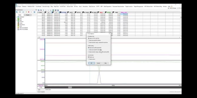
Magnetic Surveying for anthropogenic objects: Data Processing
Good data processing is crucial to the successful completion of a magnetic survey. While often the quality of the processing relies on the experience of
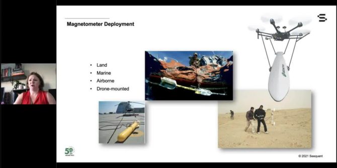
Magnetic Surveying for anthropogenic objects: Data acquisition
The theory, data acquisition and data processing. The webinars are jointly delivered by Seequent and Geometrics. Search for man-made objects in the near surface has
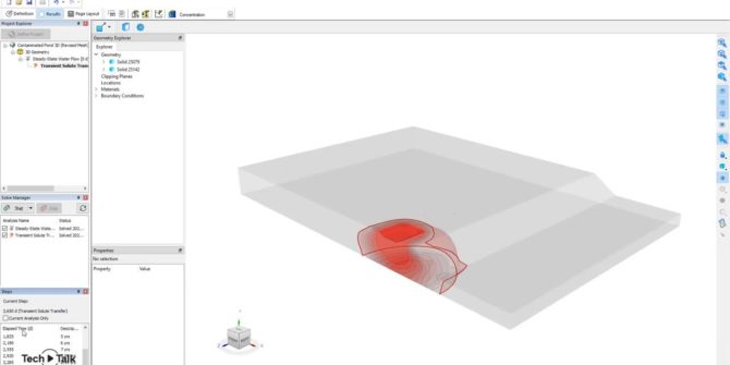
GeoStudio 2021.4 Sneak Peek: Introducing GeoStudio 3D FLOW, including CTRAN3D and AIR3D
including common use cases that can be analysed using the products, that will be included in the upcoming GeoStudio 2021.4 release. In this video, Seequent's
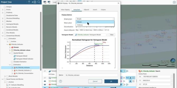
How to do Indicator Modelling in Leapfrog Works with the Contaminants Extension
Overview SpeakersPaulina Cortez Project Geologist, SeequentDuration5 minJTNDJTIxLS0lMjBUaGUlMjBzY3JpcHQlMjB0YWclMjBzaG91bGQlMjBsaXZlJTIwaW4lMjB0aGUlMjBoZWFkJTIwb2YlMjB5b3VyJTIwcGFnZSUyMGlmJTIwYXQlMjBhbGwlMjBwb3NzaWJsZSUyMC0tJTNFJTBBJTNDc2NyaXB0JTIwdHlwZSUzRCUyMnRleHQlMkZqYXZhc2NyaXB0JTIyJTIwYXN5bmMlMjBzcmMlM0QlMjJodHRwcyUzQSUyRiUyRnBsYXkudmlkeWFyZC5jb20lMkZlbWJlZCUyRnY0LmpzJTIyJTNFJTNDJTJGc2NyaXB0JTNFJTBBJTBBJTNDJTIxLS0lMjBQdXQlMjB0aGlzJTIwd2hlcmV2ZXIlMjB5b3UlMjB3b3VsZCUyMGxpa2UlMjB5b3VyJTIwcGxheWVyJTIwdG8lMjBhcHBlYXIlMjAtLSUzRSUwQSUzQ2ltZyUwQSUyMCUyMHN0eWxlJTNEJTIyd2lkdGglM0ElMjAxMDAlMjUlM0IlMjBtYXJnaW4lM0ElMjBhdXRvJTNCJTIwZGlzcGxheSUzQSUyMGJsb2NrJTNCJTIyJTBBJTIwJTIwY2xhc3MlM0QlMjJ2aWR5YXJkLXBsYXllci1lbWJlZCUyMiUwQSUyMCUyMHNyYyUzRCUyMmh0dHBzJTNBJTJGJTJGcGxheS52aWR5YXJkLmNvbSUyRkNKMmpFM3l0VkVnUFc0cGk1cWp2bXkuanBnJTIyJTBBJTIwJTIwZGF0YS11dWlkJTNEJTIyQ0oyakUzeXRWRWdQVzRwaTVxanZteSUyMiUwQSUyMCUyMGRhdGEtdiUzRCUyMjQlMjIlMEElMjAlMjBkYXRhLXR5cGUlM0QlMjJpbmxpbmUlMjIlMEElMkYlM0UlMEE= Video Transcript [00:00:00.400] <v Narrator>Welcome to Leapfrog Works</v> [00:00:02.070] and its Contaminants extension. [00:00:04.690] In this video, [00:00:05.820]
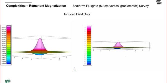
Magnetic Surveying for anthropogenic objects: The theory
The theory, data acquisition and data processing. The webinars are jointly delivered by Seequent and Geometrics. Search for man-made objects in the near surface has
GeoStudio Core: Integrating SLOPE/W, SEEP/W, and SIGMA/W to solve more complex problems
This video will take you through the step-by-step process of defining the analysis tree, materials, and geometry, followed by reviewing the results of an example
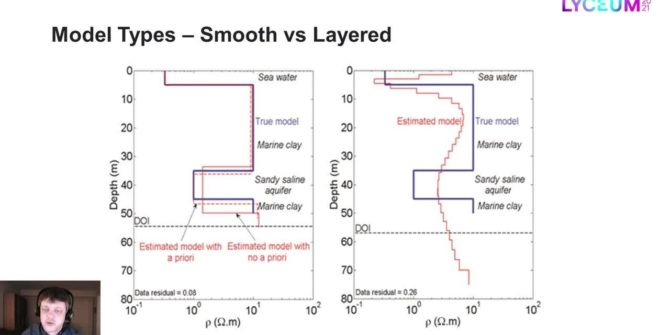
Model types for the inversion of TEM/FEM data in Aarhus Workbench
Most inversions are done with smooth models only, but often the resolution is good enough to sense more abrupt changes in the geology than the
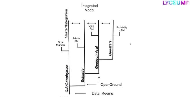
A central case study: Multi-disciplinary approach to managing big data for offshore windfarm development
This presentation explores strategic approaches for overcoming common challenges associated with modelling large multi-disciplinary datasets for offshore windfarm development.